
Advancing Air Quality, Food Security and
Human Health under Global Climate Change
Human Health under Global Climate Change
- Atmospheric Circulations Associated With Extreme Precipitation Over the Yangtze River Valley During the 2020 Meiyu Season
- How Intense Will Future Tropical Cyclone Impacts Become Due to Global Warming?
- Sustainable Farming Practices as a Means to Resolve the Worsening Food Crisis and Air Pollution Problem
- Harnessing Nature-based Solutions for Ameliorating the Impact of Global Environmental Change
- Transboundary Air Pollution and Health Impacts
- Adverse Effects of Environmental Contaminants on Human Health
|
Home / Project Highlights / Atmospheric Circulations Associated With Extreme Precipitation Over the Yangtze River Valley During the 2020 Meiyu Season
|
|
Atmospheric Circulations Associated With Extreme Precipitation Over the Yangtze River Valley During the 2020 Meiyu Season
|

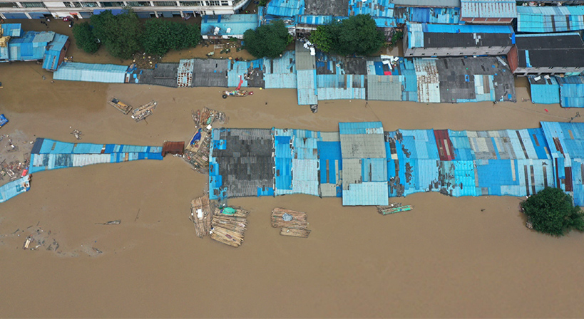
The Caiyuanba Fruit Wholesale Market in the Yuzhong District of Chongqing City was flooded. (Photo credit: Xinhuanet).
|
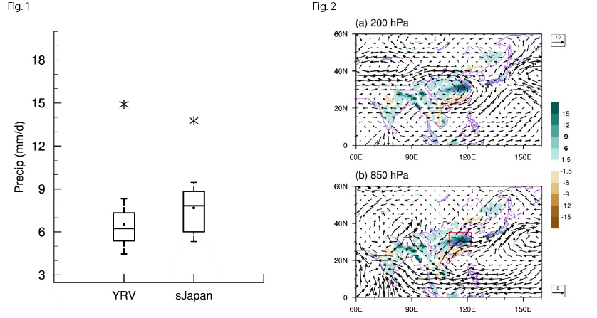
“The insights gained from this research contributes to a deeper understanding of the local dynamical mechanisms associated with severe Meiyu events, as well as improved skill in the prediction of such extreme weather events,” said Professor Gabriel Ngau-cheung Lau, the Lead Author of the study. Professor Lau’s research team observed an extreme Meiyu (Plum Rain) season in the Yangtze River Valley (YRV) in 2020 summer, with an average rain rate of 14.9 mm/day from June 10 to July 20. Throughout these 40 days, the rain rate is higher than the all-time maximum of 11.0 mm/day and is doubled its historical mean of 6.5 mm/day for the same period, according to the data records from 1979 to 2019 (left portion of Fig. 1). The record-breaking rainfall not only happens in YRV, but also occurs over southern Japan in the same summer (right portion of Fig. 1). The research team discovered that the principal precipitation center in 2020 is located at the lower reach of the YRV, and is shifted slightly northward from its typical historical position. In most summers, this Meiyu rain band is situated between an enhanced upper-level jet stream (a narrow band of strong westerly winds) to the north and an intensified lower-level jet stream to the south. This “jet stream-precipitation relationship” is particularly evident in the 2020 summer (Fig. 2), which entails the placement of the precipitating zone within the latitudinal gap between the upper- and lower-level jets. This configuration of atmospheric motions at the upper and lower levels is conducive to vigorous ascent and precipitation within the latitudinal band between the two jets. In 2020, the enhanced and poleward shifted upper-level westerly jet contributes to the slightly poleward shifted precipitation center, while the strong and stable lower-level westerly jet plays a crucial role in the persistence of the extreme event. Condensational latent heating accompanying the rising motions over YRV can in turn enhance the upper and lower westerly jet for several days. The positive feedback process between the rising motions and the westerly jets thus enhances the persistence of the extreme Meiyu episode. |

| Fig. 1 Boxplot of precipitation rate in June 10-July 20 over the Yangtze River Valley (YRV, 28°-35°N/110°-122°E) and southern Japan (sJapan, 31°-42°N/130°-142°E), as constructed based on data for the 1979-2019 period. The top and bottom of each box represent the 75th and 25th percentile values, respectively. The bar within each box corresponds to the 50th percentile value (median). The whiskers extending from the boxes indicate the 90th and 10th percentile values. Dots indicate the mean precipitation rates. Asterisks refer to the record-breaking precipitation rates in 2020. |
| Fig. 2 Anomalous (departure from 1979-2019 climatology) precipitation rates (shading, mm/day), 200-hPa winds (arrows, m/s) in (a), and 850-hPa winds (arrows, m/s) in (b) during June 10-July 20 of 2020. Red box in (b) shows the middle and lower reaches of the Yangtze River Valley (YRV, 28°-35°N/110°-122°E). Note the positioning of anomalous eastward upper level winds to the north of the principal precipitation center over the YRV (panel a), and eastward lower level winds to the south of the same precipitation center (panel b). |
|
Acknowledgement: This section of research project was supported by grant from the Vice-Chancellor’s Discretionary Fund of The Chinese University of Hong Kong (project no.: 4930744). |


